Tertiary Research Group Field Meeting on the Isle of Wight, June 9th-10th, 2007.
The stratigraphy of the Solent Group (Eocene-Oligocene) of the north-east coast of the Isle of Wight.
Leader: Andy Gale
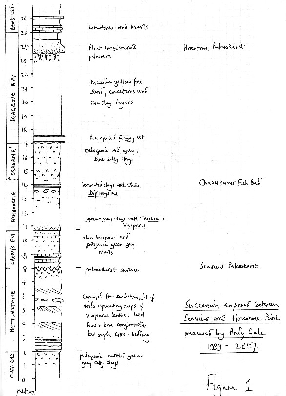
Day 1, Saturday 9th June: The succession between Seaview and Horestone Point (Figure 1).
The shore north west of Seaview is occupied by mottled yellow-orange and rarely green pedogenic clays and silty clays of the upper part of the Cliff End Member which are usually covered by superficial sand. A thin unit (0.5 m) of pale laminated silts and locally cemented sands forms a shore parallel arc, approximately 10 metres beneath the top of the Member.
The shore on the point at Seaview exposes the lower contact of the Nettlestone Member. The basal bed is a 0.05-0.1 m thick limestone made up of small gastropods and charophytes, overlain by a succession of well bedded sands, 0.2 – 0.5 m thick. The sands are laminated and rippled and one surface reveals meniscate, backfilled burrows. The main part of the Nettlestone Member comprises cemented sands full of comminuted shell debris voids, and scatters of gastropod moulds of Viviparus lentus. Low angle planar cross-sets are visible, and occasional conglomeratic lags of flints and bone material are present. The sands show very irregular concretionary cementation. The highest metre of the member is massive and very calcareous and was formerly worked as a freestone. The summit is an irregular karstic surface, called the Seaview Karst, with topography of about 0.5 metres, which represents the base of the Lacey’s Farm Member. Karstic solution hollows full of pale green clay extend over 1 metre down into the Nettlestone Member, and the shallow depressions on the surface of the karst contain rounded blocks of shelly limestone in a matrix of broken shells. The infills and overlying marly pale yellow limestone contain thin hard laminated layers.
The Lacey’s Farm Member occupies the shore between the base of the High Street and the slipway adjacent to the Old Boathouse and is 2.7 metres thick at Seaview, and comprises alternations of pale yellow and grey marly limestones and green-grey pedogenic marly clays. Moulds of gastropods are locally common (Viviparus, Galba).
Pale green clays of the uppermost Lacey’s Farm Member are overlain by dark grey-bluish clays of the basal Fishbourne Member which contain abundant Tarebia. The contact is rarely exposed adjacent to the sea wall. The Chapelcorner Fish Bed is sometimes seen on the shore to the south. Slipped masses at Horestone Point expose the Osborne and Seagrove Bay Members, and the Bembridge Limestone.
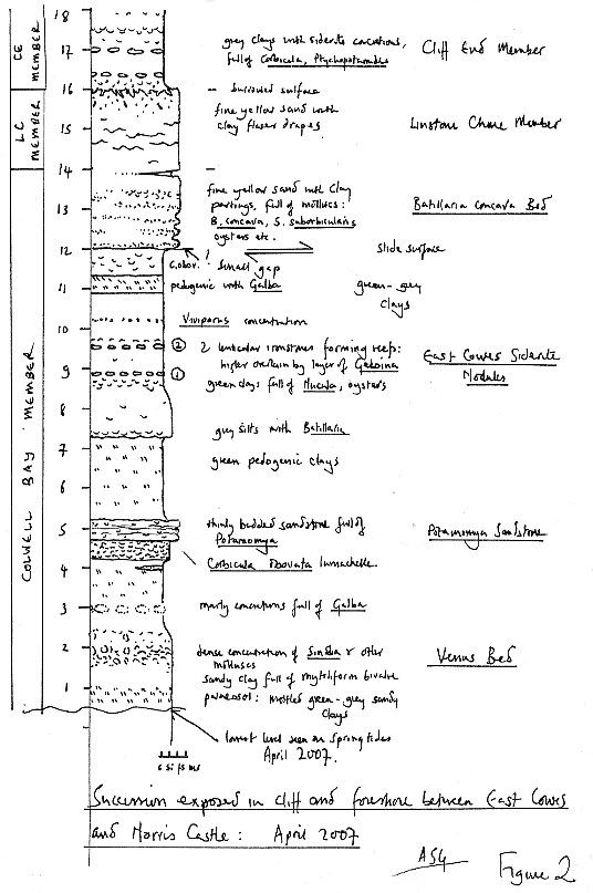
Day 2, Sunday 10th June 2007: The succession between East Cowes and Norris Castle (Figure 2).
A remarkable succession of nearly 20 metres of the Solent Group is exposed on the foreshore and in low cliffs east of East Cowes. Although few, if any, 20th or 21st century geologists appear to have visited these sites, the succession was described in exceptional detail by Bristow (in Forbes, 1856), and all of his described horizons can be recognized.
14 metres of Colwell Bay Member are exposed on the foreshore on low spring tides, including a richly fossiliferous development of the Venus Bed (not recorded by Bristow), fossils from which strew the beach, including bivalved Sinodia suborbicularis, widely mistaken for modern shells by the public. A thin sandstone containing Potamomya and Tarebia forms a distinctive reef near Norris Castle Point, and overlies a Corbicula obovata lumachelle. This unit is widely repeated by slumping.
Two thin, distinctive sideritic concretionary bands (0.5m apart) outcrop on the foreshore, and are developed in highly fossiliferous clays. The higher band is overlain by a layer full of convex-up Geloina pulchra, exactly as described by Bristow in Forbes (1856). The overlying succession contains beds of grey and greenish clays containing Galba and Viviparus.
The uppermost 6 metres of the succession are only exposed in slipped masses which appear superficially to be in situ, but actually are landslips. The succession has been checked and completed by reference to the East Cowes borehole (Whitaker 1910). A very fossiliferous development of the Batillaria concava Bed is exposed in slips and gaps in the Norris Castle sea wall. This contains a more marine fauna than that seen on Headon Hill. Immediately above, nearly 2 metres of the Linstone Chine Member are present, comprising fine sands with thin clay drapes. These are surmounted by the basal surface of the Cliff End Member, which is piped down in burrow fills. The lower Cliff End Member here comprises silty grey clays with sideritic concretionary levels, containing abundant Corbicula obovata and Ptychopotamides. Above, Potamomya shell beds are well developed.
Edward Forbes and the Isle of Wight
Forbes’ classification of the fluvio-marine sediments of the Island was strongly influenced by his studies of the coast section between St Helens and Nettlestone, a region now known as Seaview. He established (1853) the St Helen’s Series, immediately underlying the Bembridge Limestone, which was divided into the Nettlestone Grits below and the St Helen’s Sands above, the two separated by clays (1856). The name was subsequently changed to the Osborne Series after his visit to the cliffs and grounds adjacent to Queen Victoria’s residence, Osborne House. Forbes described the beds in detail on the coast between St Helens and Seaview and later applied this classification in a traverse along the north east coast of the Island. The description was quoted verbatim by several authors (e.g. Bristow et al. 1863,1889; White 1921) some of whom did not visit all the localities. The 150 year old classification was repudiated in a paper describing the lithostratigraphy of the Solent Group by Insole and Daley (1985) who suggested that landslipping had repeated the succession around Seaview, creating the spurious impression to Forbes that two sandstones units were present.
Recent study of the succession exposed at Seaview has confirmed the detailed veracity of Forbes’ observations (Gale et al. 2006) and lead to the resurrection of a Nettlestone Member. Subsequently, remapping and detailed logging of the northeast coast of the Island has lead to further reappraisal of the stratigraphical nomenclature.
Forbes account is accurate and detailed for the most part, but he was evidently confused by landslipping and the reptition of strata which it caused. At Horestone Point, blocks of pebbly sandstone derived from the uppermost few metres of the Seagrove Bay Member
litter the shore, and are aligned in shore – parallel rows representing successive landslips of the hard, competent upper Seagrove Member and Bembridge Limestone over Osborne Member clays. Forbes saw these as upfaulted in situ Nettlestone Grit, and this interpretation probably influenced Insole and Daley’s (1985) conclusion that this unit was simply a landslipped repitition of their Seagrove Member.
EDWARD FORBES, 1815-1855
1842 Curator of the collections of the Geological Society of London
1844 Palaeontologist to the Geological Survey
1853 President of the Geological Society
1853 Professor of Botany, King’s College London
1854 Professor of Natural History, University of Edinburgh
Edward Forbes (1815-1855) was one of the most remarkable palaeontologists and zoologists of early 19th century Britain. He described numerous British fossil echinoderms and molluscs, living asteroids and medusae, and undertook pioneering work on biogeography, including the depth distribution of marine benthic organisms and the distribution of British fauna and flora. He published two important stratigraphical monographs, on the Purbeck Series in Dorset (1850) and the Fluviomarine Series of the Isle of Wight (1853, 1856). Edward Forbes visited the Island on numerous occasions between 1848 and 1853, and a summary of his work on what is now called the Solent Group was published the Quarterly Journal of the Geological Society (1853), and a posthumous memoir published with notes by Bristow (1856).
Selected bibliography.
Bristow, H.W., Reid, C. & Strahan, A. 1863. The Geology of the Isle of Wight. Memoir of the Geological Survey of the United Kingdom (1stnd edition). 138pp.
Bristow, H.W., Reid, C. & Strahan, A. 1889. The Geology of the Isle of Wight. Memoir of the Geological Survey of the United Kingdom (2nd edition). 138pp.
Forbes, E. 1853. On the fluvio-marine Tertiaries of the Isle of Wight. Quarterly Journal of the Geological Society of London, 9, 259-270.
Forbes, E. 1856. On the Tertiary fluvio-marine formation of the Isle of Wight. Memoirs of the Geological Survey of Great Britain. Longman Green & Longman.
Gale, A.S.,Huggett, J.M., Palike, H., N.J.,Laurie, E., Hailwood, E.A.& Hardenbol, J. 2006. Correlation of Eocene-Oligocene marine and continental records: orbital cyclicity, magneto- and sequence stratigraphy of the Solent Group, Isle of Wight, UK. Journal of the Geological Society of London,163, 401-415
Insole, A & Daley, B. 1985. A revision of the lithostratigraphical nomenclature of the Late Eocene and Early Oligocene of the Hampshire Basin. Tertiary Research 7, 1-67.
Whitaker, W. 1910. The water supply of Hampshire (including the Isle of Wight). Memoir of the Geological Survey of the United Kingdom. 252pp.
White, H.J.O. 1921. A Short Account of the Geology of the Isle of Wight. Memoir of the Geological Survey of the United Kingdom. 201pp.